THE WEATHER TO COME: FINDE SCRAMBLED WITH SNOW IN ARAGON
Saluti a tutti ...
Bulletin issued on Thursday January 27, 2011 at 19:00
General situation and trends: Stormy over the country. Rain and snow these days When cold air we have on the Peninsula is compounded by the arrival of a storm coming up from the south which will turn on us the next day. So for now moist air comes from the south, a bit warmer, but collided with the cold air prevails in Aragon, we are going to snow in the center of Aragon (and Zaragoza) for the morning on Friday and Saturday. With progress in both days, the snow level will go up and as rain below 800-1000m in the center of Aragon. In the Pyrenees it is expected a good snow (elevation 800m) for the evening of Friday, after on Saturday from South spoiled before noon with another snowfall somewhat weaker (later in French).
Between Saturday and Sunday, the storm will drift towards the Mediterranean, rolando on Sunday the flow from south to north (North East) and changing tables, wiping the skies in Aragon and covering the French Pyrenees and the border. So, perhaps Sunday covered in the Pyrenees and sunny in the Ebro Valley Follow the cold environment these days, dimensions of 400m x snow in the morning and up to 800-1000m at noon. Abrigarses. Eye roads. Environment troubled, uncertain and poor reliability prediction.
NOTE: stormy This "revolving" on the country, tends to behave not unlike a cold drop, whose behavior is very predictable. This is why forecasts written here have for this weekend very poor reliability. Cójanse with many reservations. Sorry.
Today Thursday, 27 January: Very gray in Aragon, with some sun in the Pyrenees Pyrenees In today have had a day of sun and clouds, more clouds being late hour. Gray will continue tonight but only slightly.
In Zaragoza we had such a gray, but no rain until this afternoon, getting some light rain. We have not spent as 6 º C and winds were blowing between weak and moderate E.
rains are now coming from the south to the center of Aragon , with a coat of snow begin to 800m, lowering to 500m overnight or even at the level of Zaragoza, ceasing at dawn. So, come rain this evening and perhaps sleet tonight at Zaragoza.
FRIDAY 28 JAN: SNOW COMES FROM SOUTH TO ARAGON. SNOW IN ZARAGOZA
Pyrenees In heaven will be filled during the morning, arriving at the snow English Pyrenees between mid-morning and noon and downloading mainly on the southern and border. Nevará moderately, with snow level around 800m and with moderate winds from the south. Expect about 15-20cm of snow. Iso 0 ° being about 1.200m, with temp in the valleys of -3 / 4 º C. In the French Pyrenees to the north, the snow will be very weak and will stand with cloudy skies and no rain soft throughout the morning and noon. Snowfall on the English side will stop around midnight, giving a respite to the new south front come Saturday. Eye crossings closed by snow maybe ...
In Zaragoza We overcast dawn and snowing in central and southern Aragón, raising the rainfall in the north of the region formed the morning progresses. Thus, possible snow in Zaragoza tomorrow morning, which would rain around midday. Temp in capital 0 / 5 º C and light winds from the SE, which will be strong in the south of Aragón. Will mostly cloudy day with rain weak, which will be subsiding at the end of the afternoon, leaving a dry final day. Winds SE slack.
Truce of rainfall during the night of Friday to Saturday SATURDAY 29 JAN: CONTINUED FROM THE SOUTH. X THE SNOW ZGZ TOMORROW. SNOW COMES AT NOON TO PIRINEO
In Pyrenees covering skies again from the south during the morning, with arrival of snow to the south side weak Pyrenees just before noon. In the French Pyrenees, protected by fohën, endure veiled skies and no rain all morning, the skies thickened after noon and weak snow arriving early in the afternoon. Follow the gentle flow south. Iso 0 ° being about 1.200m, with snow level to about 700m on the English side and 1.000m in the French side. Temp in the valleys of -3 / 3 ° C. In ski -6 º C. In the afternoon snowfall will continue in the Pyrenees and light winds will veering south to NE.
In Zaragoza could dawn with snow again weak to roam the snow level to the 300-600m 1 st hour, going to rain before noon. So very cloudy skies and possibly snow to 1 st hour. Temp in the capital of 1 / 6 ° C. Precipitation (snow-rain) will continue at noon and again referring to late afternoon. They are expected to moderate to 1 st hour and then dispersed weak during the afternoon, although the current pattern is very chaotic and unpredictable (all can happen). Variables x light winds in the morning, veering to northwest in the afternoon. Dusk and dawn after dry.
During the night between Saturday and Sunday are expected snowfall of NE that will affect the French Pyrenees, with snow level to only 600m, eye.
SUNDAY 30 JAN: ROLA TO NORTH. SOL CENTER IN ARAGON. WEAK IN SNOW AND BORDER
French Pyrenees Pyrenees In very cloudy skies from dawn, with weak snow that will affect the French Pyrenees border since dawn. Initial snow level to 500m, rising to 900m after noon. Will the rest of the day with overcast skies and snow weak, especially on the French side and border. Expect about 50-10cm in total. The winds will be weak from NE. Iso 0 ° being about 1.200m, with temp in the valleys of -3 / 2 º C. In ski -8 º C.
In Zaragoza sunny day with few clouds and no rain, with gale subtle. Cold environment, with temp -1 / 6 ° C. Pleasant the sun in the middle hours of the day but cold early morning and after dusk. Keep warm.
Trend post: Monday very variable. Snowfall in the Pyrenees of Navarre and Catalonia. Aragonese Pyrenees variable, with sunny spells. Keep the cold Very difficult to refine further the trend because it is not very defined. On Monday following the cold weather, mostly cloudy and rain in the Basque Country and Navarre Pyrenees, variable skies Aragonese and Catalan persistent snow, with smooth flow and cold NE.
variables also in Zaragoza skies with sunny spells and, in principle, only slightly. Temp in the capital -1 / 7 º C and mild north wind.
On Tuesday paints moist flow from the East, with significant precipitation in the Mediterranean coast, which will start during the night of Monday to Tuesday (eye), giving the snow Tuesday in Teruel and in the Catalan Pyrenees, with this flow. In general, predicting very uncertain.
Altitoy 2011 Weather: snow x Friday afternoon. Saturday "south" somewhat gray but dry. Domingo "north", snow
Friday afternoon: Snow on the English side, roads
eye Eye snow during the afternoon on the south side of the Pyrenees and the border, with elevation of about 600 - 800m and expected about 15-20cm. In Luz Saint Sauveru precipitation will be very weak fohën and the snow level will be about 1.100m. Eye passes. Portalet wrong. Somport, perhaps something better. Even better for San Sebastian to Madrid, Navarra and Basque or by Toulouse for the Catalans. The Manic try the Somport. Chains and / or snow tires. Pass?
Saturday: The morning holds dry, evening, breaking down after the race. Snowfall weak x afternoon
seems that the new head of South coming from Spain did not reach Bareges until midday, so that the race of 1 day could be completed without snow, skies veiled, it will thicken as progress morning, to be followed by a gray afternoon and already weak snow after noon. Iso 0 ° to 1.400m. Light Temp -2 / 4 ° C. Temp race around -6 º C at 2000m. Keep warm.
current Innivation : To this day he remains in deficit for the end of January, with snow beginning to be continuous between 1.700 and 1.900m in the northern slopes with a thickness of only 20cm to 1.900my up to 50-80cm to 2.100m Above the thickness is 2,400 meters above, with higher accumulations in shady and concave, where snow is stored more easily. The snow is hard on both sides, softened in the sun on the southern slopes. Snowfall expected for these next few hours in very low levels will change finally snowy landscape of our Pyrenees.
recent snowfall: snow There have been no interest in the last 10 days
snowy mantle Stability: Manto stable. Snowy Friday in front and plaque formation in North slopes
The mantle is generally stabilized after 10 days with little rain and cold temperatures. However, on Friday afternoon and evening x expect a new 20cm of snow will fall to the bottom of the valleys and winds coming from south and southeast. These guidelines snow will form plaques in the north and NW, facing the Saturday and Sunday will come out with overloads weak.
another arrives Saturday nevada south at noon, somewhat weaker and less wind. On Sunday it seems that the English side will be less loaded, but can also fall on the border 5cm. So, the picture will change significantly. There are these snow with high winds, but it will increase the risk of avalanches to Moderate (2) in the French Pyrenees and perhaps Considerable (3) in the Aragonese Pyrenees, on Saturday and Sunday.
The most dangerous slopes on Saturday and Sunday will be the north, stretching from NW to NE (including W), which are the largest formation of plaques should be sustained. The southern slopes are less prone to plaque formation, but it is difficult to ensure their safety, leaving these slopes at moderate risk (2).
These snow fall on hard snow at altitudes above 1,800-2.000mm, whose frozen surface can act as a slip plane, mainly in the northern slopes. At lower levels it will snow on the ground, solidifying much less the new thickness.
During snowfall may also cause snow avalanches naturally, although small or medium size. Avalanches are not expected merger, unless there are clear hot sun on Sunday that time the southern slopes, causing some small lava flows. Trend
later: the moment can not estimate a risk beyond Sunday to see the amounts of snow received. Without changes, including 3 in the north and 2 in the south.
And this "unreliable" bulletin sent Thursday gentlemen. Pinta
stirred, variable and uncertain. Do not pay much attention to these lines, watch the sky before going outside. Good
winter weekend a tutti ... Jorge García-Dihinx
 Champi, lideradno the group in the final ramp to the first hill Saturday
 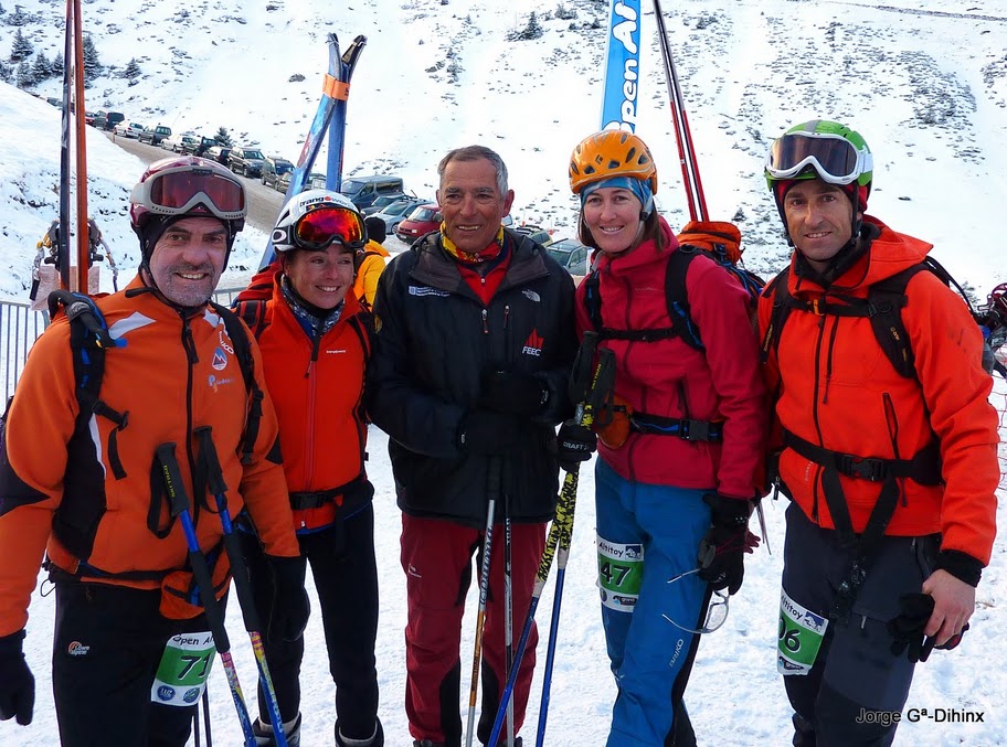 Champi, Isabel San Juan, Feliu Izard, Marie-Claude Tourillon and Jorge G ª-Dihinx
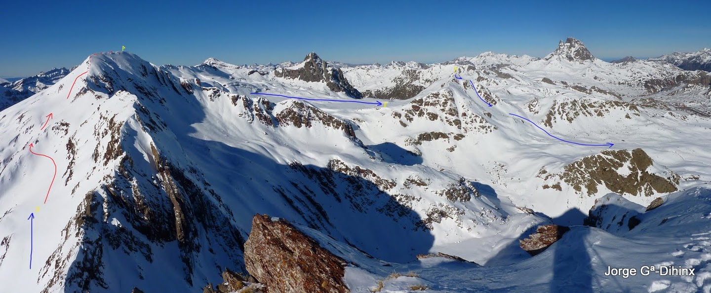
  Exit route A on Saturday 29
  The blue dawn sky. Evil comes from the south, but Tarade to arrive until noon
  An inch of snow the day before the test was a beautiful route
  Zetas Zetas and path of the first hill of the day
  Textures come magical sunny
  The row of runners, the backlight of the morning

 party end at 1 hill with skis on his back without crampons
  the background I see the ramps to the last hill of the day. The last 100 m are to crampons
  Champi leads the group that attacked on foot the last ramps at 1 col
  After spending by 1 pass, went down to walk about 200m to put of new skis and climb
  start ramps to 3 second and final pass of 1 day tour B
  This was the last photo I that day. After playing catch crampons and clouds invaded us in meters of the race last

 Ready to take the start on day 2. Poor visibility caused this was the only photo I took that day. As it turned out, we all run and really, in contrast to the 1 st day, this time we tear. What a great feeling!
  before returning to Zaragoza, I photograph my Altitoy dorsal. Until next year!