
July Benede sing well in the southern slopes of South Somol. Perfect straight carving skis with the 80 others would throw away those old having dimensions as straight. July values \u200b\u200btheir free time that having a lot of money and so with less money and more free time to live, is the happiest person in the world.
skis from Villanúa Trilogy: South Somol (2.574m), Punta Spathe (2.202m) and North Bacuna (2.191m)
Thursday February 24, 2011 July
Benede , Javi Fuentes and Jorge G ª-Dihinx
has snowed a lot the last few days and we can not be of unstable snow. Benede July I plan to become in Villanúa to climb a few steep slopes or two thousand without great risk. Javi at the moment and I have no idea what to do today. The hat of July always holds surprises.
After leaving late from Zaragoza, we get slower by the works of Monrepós and Sabiñánigo, let us stand long periods. Time is running forward (as always?) And we Villanúa at 10 am, where we met with in July. Buff, what times ... July is proposing up to Somol. Gentle slopes and guidance south and west. The Somol? Mola!
As we go without having to take permission for the track, before reaching the fence of the main track, take the turning of another track off to the right (east) and is directed toward the Source of Paco. This track does not need permission and allows access, then by road, even more quickly than by car on the track, which alternates always cut you a snow field.
So, following that track (unknown to us), about 100m before the bridge that leads to a small parking, leave the car. There appears to the left another old track that goes across country after a metal gate can be opened (a key starting point.) Start there on foot, following this track-path through the forest. We are just 1.250my although the snow begins to 1.800m, the main track of the Trapa keeps snow from the 1.600m.
But it is already 11:15 am! What tardeee! Julio, who knows by heart the easy route, urges us to remove weight of backpacks
- "Guys, we have to make time run backwards! Out weight of the backpacks! Have to risk!".
Let's see what we can throw out. Ummm ... It's hot. Outside the plumes, gloves were overweight, out crampons, ice axes and off outside water (which must then source.) We left with minimum weight, but keep the two pairs of skin, the blades in case one of these slopes were smooth hardened, a little food, few clothes and kit avalanche (avalanche transceiver, shovel and probe). In extreme times, extreme measures (even in July you know in advance that the road was not extreme, but easy, ideal for beginners. We do not. But we obey and crampons, not without some hesitation ...). They finally
11:20 AM when we left the track-path in a forest in which there until Tarzan vines! The key to keep this road that at times the set up small open areas is to follow the red marks are painted on trees and rocks. Important to follow (although we all we do is to follow in July, of course. Ha ha.)
The itinerary is always close to the river gorge Bozuelo (Or spathe). On the way we meet from time to time a fallen tree blocking a road. There comes a point where another fallen tree indicates that the path bends to the left (north) and becomes narrower. The red mark on another tree on the left to guide us back on track. Follow up by thick vegetation. In just half an hour from the car and reached the main track, about 1500m. A couple of hairpin curves on foot and skis will soon! Bieen! At the moment this goes! We started to stop the clock, which is not going forward. Has stopped! We
without water for more weight saving clear. Because you know the saying: "In the mountains have to hydrate well but there have to carry water (unnecessary). "Thus, shortly after we stopped at the booth, the refuge of plain or Cubilar Güeys of Oxen at the beginning of the valley of the spathe. Here we source of water in the trough and then we always address this in this V-shaped valley that leads to the col de Maran.'ll leave the detour to the left (sometimes less obvious) of the route that will Collarada and Collaradeta and beyond, reaching the hill Maran, turn to the left (N) to climb the southern slopes of the broad valleys of the Villanúa sheepish. The day is clear. We do not get tired fast but because we no weight, what a delight!
are only 2 in the afternoon and 2.380m, and turn, following a steep blade toward the right-hand to encircle the South Somol the left and finally attack your paddle north. We recovered the time! We made it, time goes backward! Yupiii. Concluding the northern slopes are well Somol hard, but following a good draw, we got to save them without knives (carry recommended). Arrival at the top is as soft as if it were the Quimbo or Marboré. They are a little after 14:30 and we have made top! In just over 3 short hours! The clock is running backwards!
From the top, cut to the Valley of Aurín are impressive and the views over the plateau hung Pala of Bucuesa and Ray (esquiable. .. umm ...). Remove skin and down the slopes skiing south Aurín overlooking the valley, making a nice loop. Spring snow, idyllic, which makes skied as well as "good." We met with our tracks just before the hill climb of Marano.
are still 3 in the afternoon ... Ummm ... What if we went too Punta Spathe? Well why not? We have some time back home? No! Well, by the Spathe!
Further on after a flanking we keep up to 1.820m shoulder, hung over the valley of the spathe. They stopped for lunch in the sun and put skins. What a beautiful afternoon is doing ... We still have a little less 400m to the Punta Spathe we reached at 16:15. Great vantage point of the entire south face of massive necklaces. And they two top in the afternoon! July
still keeps me another surprise. He says: - "Look George, what is missing from Harvey in his material?" Umm?? The backpack!
- "Exactly! We've left on the hill of Bacuna to further ease and so return him to complete the trilogy North subiendoal Bacuna! You do?"
- "I love it! A by Bacuna!"
said than done. We descended the hill of Bacuna skiing, where at 16:40 we are already coming up with the skins on our last summit. I have a front Javi
that foquea toward the sun and puts me in line with the sun king, giving me a dream silhouettes. And I already took over 100 photos, and I'm still shooting ...
Shortly after 5 pm there we are, two thousand more in the southern Pyrenees, watching the sunset over the Moncayo and the plains of Aragon. Which trip has been taken in July of the hat! Are
17:16 pm when we go skiing from the North Bacuna back to the track of the spathe, which then continue to ski where the snow ends, then return the way round to the car. We got there at 18:12 h after just under 7 hours of beautiful route on skis. Thanks
July to discover this area so close, so easy and noble as well as unknown, overshadowed by famous name necklaces and Collaradeta. Small
afterthought: Big mountains often look better from their satellites, sometimes even best skiing and generally have lower risk. But the ego we usually often lead to try "something big."
The next day I will try to carry on doing "something big", a new way to Tendeñera, would fail, for wanting to sell the bear's skin before the hunt.
This is the mountain, says Luis Royo: "A state of mind", so changing. Just when we thought this morning that the risk of avalanches were not going to do a humble walk, then later became, the time ran the route back and became an original trilogy. And when the next day we thought to open a new route on skis from plasterer, all would be a loophole in the valleys that descend to Linás. So the mountain is unpredictable. This time we did much more than expected. Tomorrow will happen in reverse. Continue. Jorge García-
Dihinx
To view all photos in an album in Picasa, you can click here
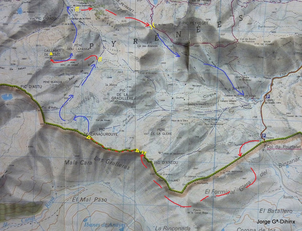
 Map Alpina 1:25.000 our journey, starting from the unknown track to be the source of Paco and that does not require permission. Then, with just 30 minutes of walking path, you're on the main track and skis soon already!
  Sunbed the V-shaped valley that leads to the hill east of Maran
  Punta Spathe Behind us, Javi and I still do not know we were going
 up after
 Leaving a large blade with soft mushrooms that we set not to tire the group
  Javi and July reaching the summit of South Somol. In the background looms the
 Moncayo
 Somol From the top of the mountain peak falls. We looked at the impressive cut that falls to the valley Aurín. Let's see if we see Francho!
  Rather than go the same place, we opted for the southern slopes overlooking the valley Aurín. Perfect spring snow in winter
  July and Javi, drawing on the ground turns soft safe
  July
July lining up again spar valley en route to a shoulder pondermos skins for up to Punta Spathe, the second peak of the day
 Javi up well guarded by the sisters and Collaradeta Collarada
  Going to Punta Spathe
  After the Bacuna down the hill, we put new skins and let the North Bacuna
  beginning the ascent Javi Bacuna . Textures backlit
  The afternoon sun backlighting creates a dreamy reflections. And all this ... it's free! You can not buy this happiness. It pleases everyone, rich or poor, but often earn it the rich in spirit
  Javi and July reaching Bacuna, our third summit of the day
  Javi and July covered the plains of Aragon with the sunset from the two thousand more to the south of the Pyrenees. Time is running backwards. The sun lights accompanied with later. Some tops for all public and usually without any public ...
  lights 5 in the evening create a magical colors. Does not blow. Not cold. No one.
  Thanks Luis for these Marville Random Movement skis so well up and down even better!
  And hurry the last km on the vang track. Later, after spending 2 saldermos hairpin curves of the path Apistan is our another track, the source of Paco
  seems that we fall down the path to the car
  and cycling through the fence, linking us to track the source of Paco. What a great day and what unexpected end, with three peaks almost unknown to Javi and me.
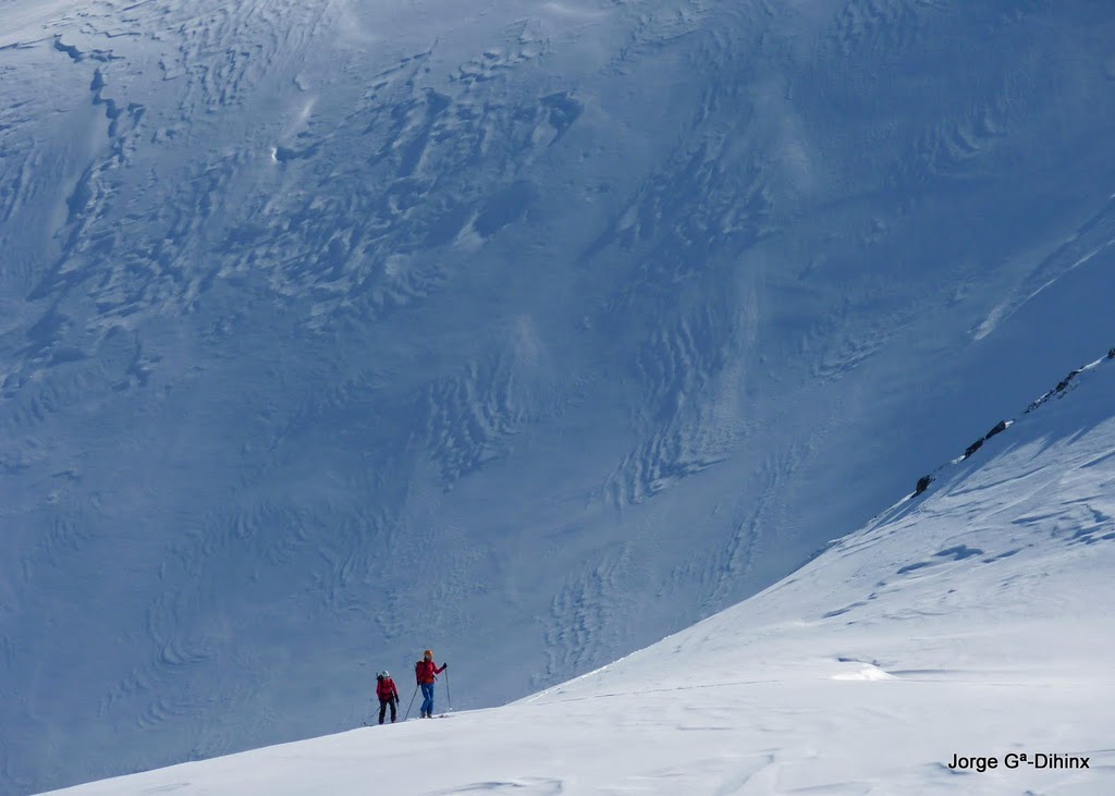


 From
From 

 We
We 


